

Yakima Skyline Trail
Where: Yakima, Washington
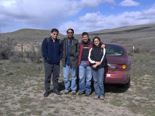
Who: Amol, Srijan, Eera, Tarun and Yogita
When: Sunday March 26, 2006
What: An unparalleled hike on Yakima Skyline Trail ( so far... :) )
This was an experience like never before. I have hiked along the Olympic peninsula, Little Si and RattleSnake ridge. This compares to none. I would consider myself a novice on this hike which seemed slightly higher in difficulty level than moderate. But in all it was the most interesting and rewarding hike.
This time it was not just the two of us, me and Tarun. We had three more friends and that added to the fun. We started from Bellevue at around 7:45 am. I had packed in stuff in my and tarun's bag based on last hike's experience. More water, already prepared sandwiches, some hand sanitizer and tissue papers. We had our new hiking shoes on. We started off in what didn't seem like a nice weather. A few miles down and it started drizzling. Well that didn't look very inviting and everyone was blaming Tarun for that... I don't know why. After some time (at 8:14:53) :) we stopped for a sad breakfast at Burger King, though Srijan's banana bread was awesome.
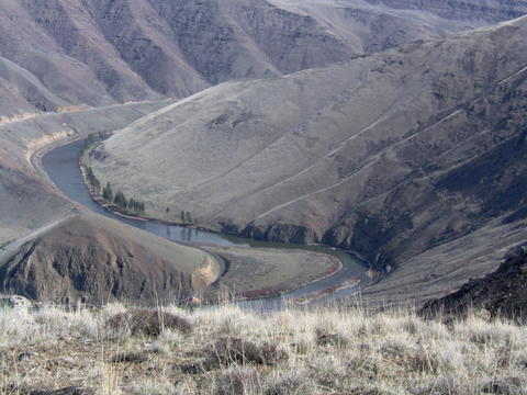
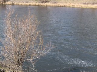 After breakfast we headed out again and as we crossed the Snoqualmie area, we saw loads of snow and it was pouring on us. There was no sign of the sun until we were close to Yakima, where a beautiful weather greeted us. Tarun knew an alternative route to Yakima which went through the Yakima canyon along the Yakima river. Only one word can describe our journey through that, breathtaking. The river was embellished with eddies and small boulders. The mountains together looked to me a like a sheet of green silk where the sunlight was giving it a new texture. Well that's as much geography knowledge I have that I am not sure if you would call those mountains or peaks. I'll keep mountains. However give any word, they stood together to form a majestic skyline.
I was so much in awe of the view that I didn't realize that none of us knew where we were headed to. Me and Tarun had both forgotten to take the directions :) (is it a usual thing? ...oh well!). We had the WA state map and following that we landed into what seemed like downtown Yakima. We stopped by Red Lion Hotel for some information. At the lobby we found a computer with internet and a printer. This was all we wanted. We took the print outs and headed back to the same place where we came from, the Yakima canyon. So we would be hiking in that picturesque terrain. The trail guide had mentioned that it would be difficult to find the trailhead and so it was but not very much. After asking a few people on the way and driving on to a fun filled bumpy ride on stones and boulders we reached the trailhead. Oh and how could I forget the confusion that everyone had about which was the actual trailhead. Srijan asked Tarun to go beyond the area which looked like a parking place. Rest of us had different opinions. Agreeing to Srijan we went ahead and that certainly was not good for the health of our city car. Road was extremely rocky and we decided that we will take the trailhead that we had seen before. So came back and parked the car over there.
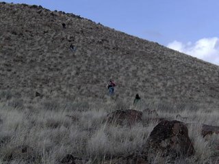
 We started off carrying our bags and clicking some pictures. The trailguide mentioned that you would see signs at the trailhead but what we saw was a metal plate with loads bullet shots in it. It was difficult to read it, nevertheless we started walking up the mountain. Tarun said that we would meet a couple of false peaks before we see the actual peak so I knew that this seemingly easy hike to the top of the first mountain was not all that was there. Well, at least for me this hike was not one of those easy ones. The elevation gain was higher than I have ever experienced before. The trail has small rocks and boulders and then my new shoes. I didn't know until after I had finished the hike that you have to wear them for some time before an actual hike. My new shoes were biting my feet and I ended up with blisters. And later I realized that so did Tarun.
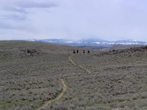
 Anyway I enjoyed the hike to the peak. I had dropped the case of my camera somewhere along the trail. But, a nice bunch of horse riders actually came out of their way to give us the case back. They had two scary dogs along with them as well. But they didn't bite me just like all other dogs that I am scared of :). As we ascended, the wind was blowing harder and it was getting chillier. But none of this could hold us back from enjoying the vista of the canyon from the top of the first peak. There was a ranch, a dam, a river and a tunnel far away. So then we set off to hike to next peak in view. Amol was leading the way. He probably was more adventurous than any of us taking risky cut acrosses and going right till the edge of the cliffs. I was clicking pictures along the way... so was Srijan. Tarun kept coming back to check on me. Following Amol, we made our way to the summit of another peak only to find that there is yet another one that is higher than the current one. We all were determined to find the highest peak so we climbed up yet again. This time as well same story repeated and we started taking turns in guessing if this was it or not...
 This last one was, but only among those bunch of peaks. There was yet another higher peak somewhat distant that looked inviting. We all sat down for some time and had lunch. As we reached up here in about 1.5 hours, we all decided we could go for that higher peak. So we set off again in quest of the highest point in Yakima Skyline Trail. This lap was probably the hardest and most adventurous for me at least. Our leader only made it harder by not taking up the trails but cutting across mountains. We even had to walk through a near vertical ( okay this is exaggeration but probably at an angle of 30-40 degrees) mountain negotiating with heavy wind. But the hiking shoes worked wonders. They gave me the confidence that I can do it and at least I was not scared :). Amol had come back to make sure we make it through safely and Tarun was already watching me and Eera cross through. Then finally we reached the bottom of that highest peak. This was another gem of a hill, very steep and very rocky. But we climbed that up as well and wow we were on what seemed like one of the highest peak. There were a few other just across the rivers that looked somewhat of the same height or a bit higher. We sat there for a while enjoying the cold wind and the aura of the Yakima canyon.
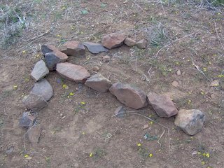 Then we headed back but climbing down the peak again through those rocks was another challenge, but that makes it more fun. Other than this the hike back was very uneventful and full of longing for the car which was way down somewhere. But we did see some arrows made of stones on the way back. We had mixed reactions on this one. Best one was of Amol though. He said what if this arrow is leading us to a deadly maniac who is ready to kill us. Well, no one believed him :) and we followed the arrow. But the next one was actually leading us the wrong way so we decided to head into the direction we thought our car was. And then after some treading along the path we reached our car. Phew ... it was a memorable hike I must say. Makes me look forward to the Grand Canyon Hike.
 After breakfast we headed out again and as we crossed the Snoqualmie area, we saw loads of snow and it was pouring on us. There was no sign of the sun until we were close to Yakima, where a beautiful weather greeted us. Tarun knew an alternative route to Yakima which went through the Yakima canyon along the Yakima river. Only one word can describe our journey through that, breathtaking. The river was embellished with eddies and small boulders. The mountains together looked to me a like a sheet of green silk where the sunlight was giving it a new texture. Well that's as much geography knowledge I have that I am not sure if you would call those mountains or peaks. I'll keep mountains. However give any word, they stood together to form a majestic skyline.
I was so much in awe of the view that I didn't realize that none of us knew where we were headed to. Me and Tarun had both forgotten to take the directions :) (is it a usual thing? ...oh well!). We had the WA state map and following that we landed into what seemed like downtown Yakima. We stopped by Red Lion Hotel for some information. At the lobby we found a computer with internet and a printer. This was all we wanted. We took the print outs and headed back to the same place where we came from, the Yakima canyon. So we would be hiking in that picturesque terrain. The trail guide had mentioned that it would be difficult to find the trailhead and so it was but not very much. After asking a few people on the way and driving on to a fun filled bumpy ride on stones and boulders we reached the trailhead. Oh and how could I forget the confusion that everyone had about which was the actual trailhead. Srijan asked Tarun to go beyond the area which looked like a parking place. Rest of us had different opinions. Agreeing to Srijan we went ahead and that certainly was not good for the health of our city car. Road was extremely rocky and we decided that we will take the trailhead that we had seen before. So came back and parked the car over there.
 We started off carrying our bags and clicking some pictures. The trailguide mentioned that you would see signs at the trailhead but what we saw was a metal plate with loads bullet shots in it. It was difficult to read it, nevertheless we started walking up the mountain. Tarun said that we would meet a couple of false peaks before we see the actual peak so I knew that this seemingly easy hike to the top of the first mountain was not all that was there. Well, at least for me this hike was not one of those easy ones. The elevation gain was higher than I have ever experienced before. The trail has small rocks and boulders and then my new shoes. I didn't know until after I had finished the hike that you have to wear them for some time before an actual hike. My new shoes were biting my feet and I ended up with blisters. And later I realized that so did Tarun.
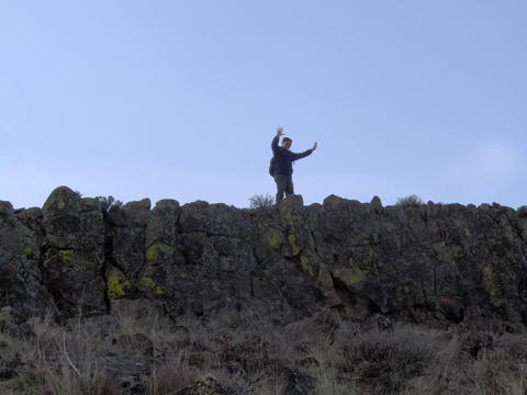 Anyway I enjoyed the hike to the peak. I had dropped the case of my camera somewhere along the trail. But, a nice bunch of horse riders actually came out of their way to give us the case back. They had two scary dogs along with them as well. But they didn't bite me just like all other dogs that I am scared of :). As we ascended, the wind was blowing harder and it was getting chillier. But none of this could hold us back from enjoying the vista of the canyon from the top of the first peak. There was a ranch, a dam, a river and a tunnel far away. So then we set off to hike to next peak in view. Amol was leading the way. He probably was more adventurous than any of us taking risky cut acrosses and going right till the edge of the cliffs. I was clicking pictures along the way... so was Srijan. Tarun kept coming back to check on me. Following Amol, we made our way to the summit of another peak only to find that there is yet another one that is higher than the current one. We all were determined to find the highest peak so we climbed up yet again. This time as well same story repeated and we started taking turns in guessing if this was it or not...
 This last one was, but only among those bunch of peaks. There was yet another higher peak somewhat distant that looked inviting. We all sat down for some time and had lunch. As we reached up here in about 1.5 hours, we all decided we could go for that higher peak. So we set off again in quest of the highest point in Yakima Skyline Trail. This lap was probably the hardest and most adventurous for me at least. Our leader only made it harder by not taking up the trails but cutting across mountains. We even had to walk through a near vertical ( okay this is exaggeration but probably at an angle of 30-40 degrees) mountain negotiating with heavy wind. But the hiking shoes worked wonders. They gave me the confidence that I can do it and at least I was not scared :). Amol had come back to make sure we make it through safely and Tarun was already watching me and Eera cross through. Then finally we reached the bottom of that highest peak. This was another gem of a hill, very steep and very rocky. But we climbed that up as well and wow we were on what seemed like one of the highest peak. There were a few other just across the rivers that looked somewhat of the same height or a bit higher. We sat there for a while enjoying the cold wind and the aura of the Yakima canyon.
 Then we headed back but climbing down the peak again through those rocks was another challenge, but that makes it more fun. Other than this the hike back was very uneventful and full of longing for the car which was way down somewhere. But we did see some arrows made of stones on the way back. We had mixed reactions on this one. Best one was of Amol though. He said what if this arrow is leading us to a deadly maniac who is ready to kill us. Well, no one believed him :) and we followed the arrow. But the next one was actually leading us the wrong way so we decided to head into the direction we thought our car was. And then after some treading along the path we reached our car. Phew ... it was a memorable hike I must say. Makes me look forward to the Grand Canyon Hike.
 posted by Yogita Bhalla | 10:02 AM
|
0 comments
![]()


